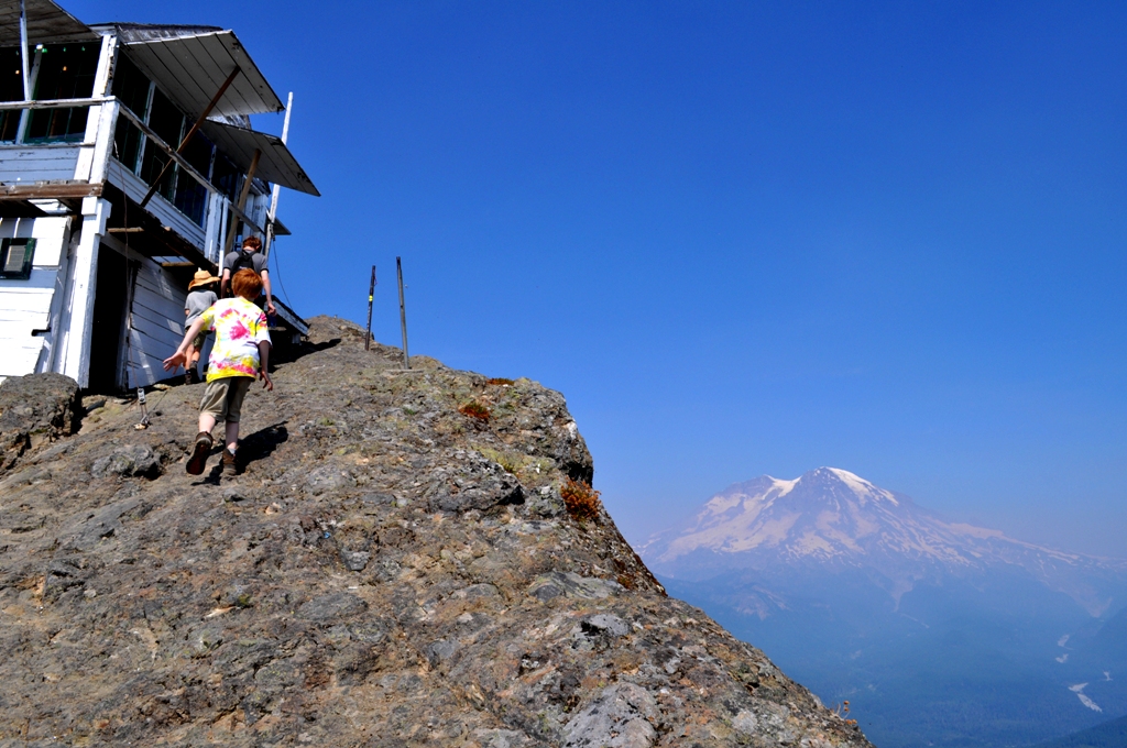
Over the years many a hiker and fire lookout volunteer have waxed poetic about the breathtaking High Rock. Standing at the top of the highest lookout in the Gifford Pinchot National Forest has a way of putting life in perspective; one feels his human smallness and the vast shifting beauty of the world around us. With clear skies in the forecast, my family and I recently decided to head up and see what we could see.
 On a dry day we arrived in a cloud of dust at the trailhead to High Rock, and I instantly questioned the wisdom of hiking to the top in warm weather with my kids, the youngest being ten years old. With extra water bottles, the ten essentials and a picnic lunch, the five of us set out. The 1.6 mile climb started immediately though, in retrospect, the first half of the hike is quite gradual. After a couple switchbacks, we met up with a family descending with two girls slightly younger than my daughter. I thought to myself, “If they can do it, my daughter can do it.” The switchbacks are brief, and then the hike begins to follow the ridgeline.

The heat of the day did not matter as much once we were on the trail. It is always cooler in the forest, and much of the hike is shaded with only a few exposed areas along the way. We enjoyed watching chipmunks and various birds, varieties that I never see in the lowlands, whenever we stopped to rest. However, we did not stop for long because flies were a plague. It was at this point that I felt the deficiency of the bug spray in my pack.
During our ascent we met two young men coming down the trail who asked whether we had enough water. I said that we did. They were not the last to offer us water. There is no water on High Rock, and no natural water source along the way, so water filters will not help you if you run out. It seems to be common practice for expert hikers to take extra water on this hike and even leave some bottles for “newbies” at the top. It is advisable to take at least two, large water bottles per person.

The hike to the top was challenging for my family, but we made it without major mishap. The climb is steady and steep at times, and the air seemed a bit thin, but that could have been my imagination. There are a few nice overlooks to stop at and catch one’s breath in order to remember why we were going 1.6 miles uphill.
Once you reach the top, nothing prepares you for the sensation of looking out from such a height without a handrail. Perhaps the best descriptor is exhilaration with a touch of vertigo. The pillar formation on which the fire lookout is perched is solid rock and a pleasant place to sit and enjoy a picnic. On a very clear day Mt. Rainier, Mt. Adams and Mt. St. Helens are visible
High Rock History

The fire lookout, which is one of only three remaining in the Lewis County portion of Gifford Pinchot National Forest, is worthy of a visit for its historical significance and was listed on the National Register of Historic Places in 1997. The register has this to say about it, “Undoubtedly one of the most spectacular lookouts in America, High Rock is on the Gifford Pinchot National Forest just south of Mt. Rainier National Park. The 14′ x 14′ gable roof L-4 ground house with catwalk was built in 1929 and staffed the same year. It is perched on the edge of a 1200′ sheer cliff.”
The lookout was staffed by the Forest Service until the 1970s and was maintained by volunteers until 2004. The most notable was the late Lawrence “Bud” Panco of Packwood, who volunteered from 1985 to 2004. In the September 29, 2008, interview with the Chronicle, Panco expressed his belief that the fire lookouts with the human eye are the best way to spot a fire that could be missed otherwise. High Rock in particular provides a view of a large part of the state of Washington.
“I turned in a fire out over Brothers Mountain in the Olympics. You can see parts of Puget Sound and see the lights of the Spanaway Airport,” Panco said. “I turned in six fires in the Wenatchee Forest they didn’t know were there. I turned in every smoke I saw.”

Panco was a jack-of-all-trades up on High Rock. His first priority was to watch for fires, but he also collected weather information, maintained the lookout structure and acted as a greeter to hikers from all over the world.
But in 2004 things came to an abrupt end when vandals paid High Rock a visit while Panco was out getting supplies. They left the lookout uninhabitable.
“I had my groceries ready to go, and I was all prepared to go up,” he said. “But they destroyed the kitchen, threw all the furniture out, broke the door and tossed all my tools off the edge.”
According to historian Dave Garoutte, back about 2003 some vandals set off a dynamite charge that blew off a chunk of rock between the lookout and the north drop off, and later cables that used to provide a rail along the top were also stolen as well as the lightning rod.
There have been many attempts in recent years to return the lookout to its 1929 condition, but efforts have been continually thwarted by vandals. Hikers, who carefully “Leave no Trace” on the trail, seem to forget their manners once they reach the lookout and scribble all over its edifice, remove walkway boards and other such mischief. Hopefully, through public education the vandalism will come to an end.

The White Pass Country Historical Society is working with the Forest Service to restore the High Rock lookout. They received a $2,000 grant from the Valerie Sivinski Washington Trust Fund to purchase material and supplies for restoration work. You can contact the White Pass County Historical Society if you are interested in helping or volunteering.
We took our time enjoying High Rock with the knowledge that the hike back was only 1.6 miles and downhill all the way. Everyone definitely agreed that the journey was well worth it.
Driving Directions to High Rock
From Elbe, WA, follow SR 706 east (passing through Ashford) for 10.1 miles. Turn right (south) onto Skate Creek Road (FR 52) and follow for 4.7 miles. Turn right (south) onto graveled FR 84 and follow for 6.8 miles bearing right onto FR 8440. (FR 8440 was the only turn with an orange pole at the fork. Watch your mileage since the roads are not all clearly marked) Continue 2.7 miles to trailhead at Towhead Gap (el. 4,330-feet).
This hike is free and requires no special permits. For up-to-date information and trail conditions, contact the Cowlitz Valley Ranger Station in Randle.


